
Hawaii is sinking 40 times faster than previously predicted: study

Paradise lost?
California isn’t the only coastal oasis that’s at risk of submersion. Scientists have revealed that certain regions on the island of Oahu, Hawaii are sinking into the sea 40 times faster than predicted, which could jeopardize homes and businesses.
Conditions have gotten so dire that low-lying areas in Honolulu, Waikiki and Pearl Harbor could be inundated in the coming decades with infrastructure damage projected to cost billions of dollars.
“In rapidly subsiding areas, sea level rise impacts will be felt much sooner than previously estimated,” said Kyle Murray, a geophysicist at Honolulu’s University Of Hawaii at Manoa who co-authored the apocalyptic study, which was published in Communications Earth & Environment, according to Earth.com.
The team was investigating the effects of sinking land masses amid the surge in rising seas due to climate change, which they felt could combine to cause extreme flooding in Oahu.
“Rising sea levels due to climate change are already increasing coastal flood risks in low-lying neighborhoods around Honolulu, and this new study shows that sinking land could significantly amplify those risks,” Dr. Kristina Dahl, vice president for science at Climate Central, told the DailyMail.com.
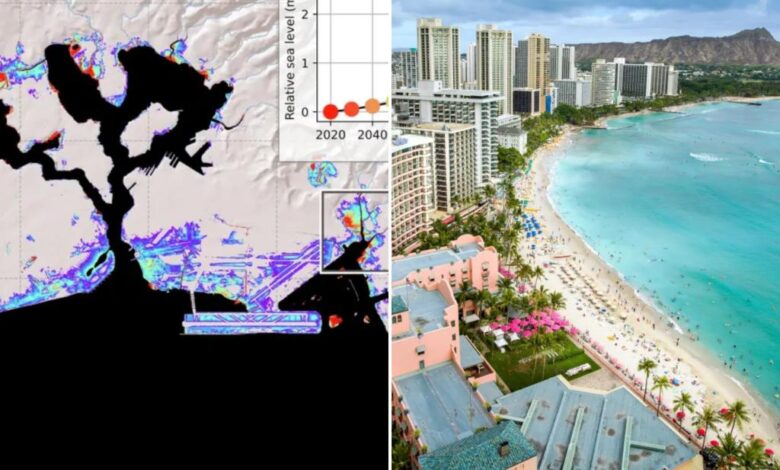
To examine this phenomenon, researchers spent nearly twenty years analyzing satellite data from the Hawaiian Islands, “referencing them with Global Navigation Satellite System measurements to calculate subsidence rates,” per the study.
The scientists mapped the coastal topography with a high-resolution digital elevation model and then utilized geospatial analysis to record the subtlest shifts in elevation.
This allowed the team to devise a model that showed how plunging land coupled with ascending sea levels could exacerbate flooding in certain areas.
Hawaiian islands slowly submerge the further they are out from the Big Island — this process has shaped the chain for millions of years — due to their weight and the movement of tectonic plates underneath them.
However, the shifts the team found were unprecedented.
While Oahu’s annual subsidence rate was only around 0.6 millimeters annually — about the thickness of ten sheets of printer paper — certain coastal regions were clocked at 25 millimeters per year — 40 times faster, per a release by the University Of Hawaii at Manoa.
This also blows away Hawaii’s average subsidence rate of 1.54 millimeters annually since 1905.
The industrial region of Mapunapuna on the island’s south shore is at particular risk because it’s built on sediments and “artificial fill,” Murray said. “We think the majority of subsidence is related to the compaction of these materials over time.”
When coupled with flooding, subsidence could increase this area’s flood exposure “by over 50% by 2050, while compressing flood preparedness timelines by up to 50 years,” according to Phil Thompson, study co-author and director of the University of Hawaii Sea Level Center in Honolulu.
By the year 2080, flooding will become more prevalent in Waikiki, downtown Honolulu and Daniel K. Inouye International Airport as well, which could have major societal impact, SFGate reported.
“Hawaii tourism, coastal development, and ecosystems will face major disruptions,” study authors wrote. “It is projected that over $12.9 billion in infrastructure is at risk from flooding and related damages on Oahu alone.”
Scientists hope that their research will help policy-makers formulate strategies to help mitigate the risk of the deluges.
“Our research provides critical data that can inform state and county decision-making, helping to improve flood exposure assessments, infrastructure resilience and long-term urban planning,” said Chip Fletcher, co-author and director of the Climate Resilience Collaborative at the University of Manoa. “This work directly serves the people of Hawaiʻi by ensuring that local adaptation strategies are based on the best available science, ultimately helping to protect homes, businesses and cultural areas.”