
Earth from space: Antarctica’s ‘Deception Island’ is one of the only places on Earth where you can sail into an active volcano
QUICK FACTS
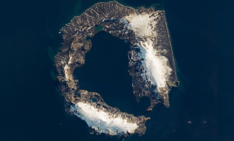
Where is it? Deception Island, South Shetland Islands [-62.953381585, -60.627783743]
What’s in the photo? A semi-submerged, active volcanic caldera partially covered in snow
Which satellite took the photo? Landsat 8
When was it taken? March 23, 2018
This striking satellite photo shows off the unique shape of Antarctica’s “Deception Island” — a semi-submerged, active volcanic caldera created by one of the region’s largest known eruptions, which now provides a haven for ships and researchers exploring the area around the South Pole.
The horseshoe-shaped island, which is roughly 9 miles (14.5 kilometers) wide, is located in the Southern Ocean around 65 miles (105 km) from mainland Antarctica. It is one of the South Shetland Islands, which sit in the middle of the Drake Passage — a stretch of water commonly known as the “iceberg graveyard,” due to the number of massive ice slabs that fall apart as they move through this passage, after breaking off from Antarctic ice sheets.
Deception Island gets its intriguing name because, from sea level, it looks like a single solid landmass surrounded on every side by steep cliffs. But if you approach it and find the narrow 1,600-foot-wide (500 meters) opening in the caldera’s rim, known as “Neptune’s Bellows,” you realize that it holds a massive hidden lagoon.
Explorers first discovered the secret passageway in 1820. Before then, many sailors would have likely passed by not knowing that its interior, known as Port Foster, is an excellent refuge for sailors to wait out massive storms that frequently hit the Southern Ocean.
Related: See all the best images of Earth from space

The unusual landmass was left behind after a major volcanic eruption around 4,000 years ago, which likely launched between 7 and 14 cubic miles (30 and 60 cubic kilometers) of ash and magma into the sky — the equivalent of between 120 million and 240 million Olympic swimming pools. Experts believe this was the largest eruption in Antarctica for at least the last 12,000 years, according to NASA’s Earth Observatory.
The island is still volcanically active and has hosted at least 20 small eruptions since the end of the 19th century. However, it has not erupted since 1970 and has been silent since 2015, when the last seismic activity was recorded on the island, according to the Smithsonian Institute’s Global Volcanism Program. There is only one other active volcano in Antarctica — Mount Erebus on Ross Island.

Today, Port Foster is home to two permanent research stations run by Argentina and Spain, according to the British Antarctic Survey. A third station, belonging to Chile, was also located on the island but was destroyed during the 1970 eruption.
There are also between 50,000 and 100,000 breeding pairs of chinstrap penguins (Pygoscelis antarcticus) that call the island home, alongside several species of seals and seabirds, according to the BBC.
Deception Island is also visited by thousands of tourists every year who journey to the remote island on cruise ships and come ashore to enjoy volcanic springs along Port Foster’s beaches.